

The analysis of pedestrian traffic usually begins with an apparently simple question: how many people pass by this point? That question starts from a conceptual limitation. It measures a specific phenomenon without first understanding the system that generates it. Human beings deciding to take routes from one location to another for a purpose.
In complex urban environments —in Portugal, for example, Lisbon, Porto, Braga, Coimbra, Faro or Setúbal— pedestrian traffic is not simply a flow of people; it is the aggregate result of millions of individual decisions shaped by residence, work, transport, leisure, tourism and consumption. That is why the difference between measuring isolated points and having a structural estimate for the entire urban network is not an incremental improvement: it is a paradigm shift.
Methodology: agent-based simulation, predictive models and Monte Carlo methods
The structural estimate we propose is based on agent-based mobility simulation, combined with activity-based approaches, Monte Carlo techniques and mathematical models for territorial calibration.
In simplified terms:
- Individuals (agents) are modelled with origin and destination characteristics.
- Movement probabilities are assigned according to activity: work, leisure, return trips, tourism.
- Hundreds of millions of trajectories are generated on the real urban network.
- Pedestrian passages are aggregated by street segment.
- The result is calibrated using predictive models trained with public mobility data from Spain.
The use of Monte Carlo techniques makes it possible to simulate complex probabilistic distributions where deterministic calculation would be unfeasible. The activity-based approach allows us to represent decisions linked to real activities, not just abstract trajectories.
The calibration relies on a simple but very powerful logic: in Spain we have public mobility matrices and data based on mobile phone records. From them, we train mathematical models capable of predicting those mobility patterns using territorial explanatory variables that we can also build in Portugal: resident population, working population, urban density, commercial offer, tourist attractors, transport, road structure, centrality, distance between zones and characteristics of the urban environment.
Once this relationship has been learned in Spain, the model can be applied to Portugal, not as a copy, but as an analytical extrapolation based on equivalent Portuguese territorial data. The result is a structural estimate of pedestrian traffic for millions of urban street segments.
The structural problem of point-based measurement
All traditional methods for measuring pedestrian traffic in front of stores share one essential characteristic: they are partial by design.
- A manual count measures a specific point during a specific interval.
- A sensor covers a delimited area.
- An SDK dataset observes a sample conditioned by app penetration.
- Mobile phone data aggregate movements at a macro scale.
In all cases, the analyst must decide in advance where to measure.
And that decision introduces three fundamental risks:
- Selection risk: measuring where activity is already suspected.
- Omission risk: failing to detect non-obvious opportunities.
- Comparability risk: mixing heterogeneous methodologies.
When a structural estimate of pedestrian traffic is available for millions of street segments, the logic is reversed: points are not chosen in order to measure them; analysis starts from a complete map.

The benefits of agent-based mobility simulation compared with other methods
Total coverage: the advantage that changes everything
Having an estimate of pedestrian traffic in Portugal that covers all urban street segments offers major advantages over previous methods:
- Any location can be analysed immediately
- No prior deployment is required
- No operational waiting time: immediate answers
- No incremental cost is incurred for each new point evaluated
- Lisbon, Porto, Braga, Coimbra or Faro can be compared under the same methodological logic
From a methodological point of view, this removes selection bias. From an operational point of view, it removes friction. And it drastically reduces cost.
Indirect calibration with public mobility data from Spain
One of the main strengths of the model for Portugal is that it does not start from scratch. The availability in Spain of public mobility data based on mobile phone records provides a particularly valuable learning and calibration layer.
The process is as follows:
- In Spain, real aggregate mobility patterns are observed from public mobile phone-based mobility data.
- Equivalent territorial explanatory variables are built: population, employment, tourism, commerce, transport, urban centrality, accessibility and road network.
- Mathematical models are trained to predict observed mobility from those variables.
- These models are then applied in Portugal, where we build the same explanatory variables using comparable Portuguese and European sources.
This allows us to transfer knowledge, not raw data. The model does not assume that Portugal moves exactly like Spain; it learns structural relationships between territory and mobility, and applies them to the Portuguese territory.
In practice, this improves the robustness of the model compared with a purely theoretical simulation, because it incorporates an empirical calibration phase based on real observed mobility.
Scalability and marginal cost
In models based on direct measurement, the cost grows linearly with the number of analysed points.
10 locations → 10 measurements.
100 locations → 100 measurements.
The marginal cost is high.
In a model based on structural simulation, the main cost lies in building the model. Once built, the marginal cost of analysing a new location is practically zero. This difference completely changes the economics of the analysis, enabling systematic and comparable analysis where it was previously not feasible.
Reducing decision time
In retail expansion, time matters.
- Preliminary identification.
- Measurement deployment.
- Waiting for results.
- Comparison.
With a structural estimate of pedestrian traffic in Portugal, the first screening can be carried out in seconds.
- Simultaneous evaluation of thousands of locations.
- Detection of non-obvious opportunities.
- Faster reaction than competitors.
- Homogeneous analysis across Portuguese cities and Iberian markets.
Methodological standardisation
A structural model provides:
- The same methodological framework.
- The same assumptions.
- The same granularity.
- The same estimation logic.
- The same ability to compare across countries.
This enables homogeneous comparisons between cities, neighbourhoods and markets, which is especially relevant for chains operating in, or evaluating opportunities across, both Spain and Portugal.
Optimised hybrid processes
Traditional process
- 50 locations → 50 manual counts.
- High cost.
- Long execution time.
Optimised process
- Structural filtering through simulation.
- Selection of the 10 locations with the best profile.
- Point-based validation using manual counts, sensors or local data.
Result:
- Drastic cost reduction.
- Time reduction.
- Higher probability of success.
- Standardisation of the initial screening.
- Better use of any available local measurement.
Intensity and composition of traffic
In addition to total coverage, simulation makes it possible to classify pedestrian traffic by:
- Work-related movements.
- Residential flows.
- Tourist mobility.
- Transport connections.
- Occasional demand linked to shopping or leisure.
A location with high intensity dominated by commuter traffic may have lower commercial potential than another with lower intensity but a higher proportion of occasional demand. In cities such as Lisbon or Porto, where tourism, public transport, commercial centrality and residence overlap intensely, this distinction is especially relevant.
Behavioural propensity
Activity-based modelling allows the motivation behind movement to be incorporated from the outset.
This enables structural estimates of:
- Probability of detour towards retail.
- Effective exposure to storefronts.
- Potential conversion.
- Differentiation between recurrent and occasional footfall.
Applications and use cases of mobility simulation
The importance of pedestrian traffic is enormous, especially in retail, but also in many other businesses and economic sectors. We have discussed use cases of a walking traffic map for a hole country as Portugal in several posts, so here is only a quick summary:
Retail and expansion
- Mass preliminary filtering of locations for optimal site selection based on estimated traffic in front of stores
- Competitive benchmarking, comparing estimated traffic in front of stores with that of competitors
- Design of an optimal network, which may include expansion, specialisation or network reduction
- Comparison of opportunities in Spain and Portugal using homogeneous criteria
Out-of-home advertising
- Estimation of qualified audience.
- Segmentation by motivation and type of movement.
- Prioritisation of media assets in commercial, tourist and transport corridors.
Commercial real estate
- Valuation of commercial assets according to their ability to generate business value
- Comparison between assets, benchmarking
- Detection of secondary streets with structurally attractive pedestrian traffic
Urban planning
- Impact simulation
- Evaluation of flow redistribution
- Analysis of local centralities and pedestrian corridors
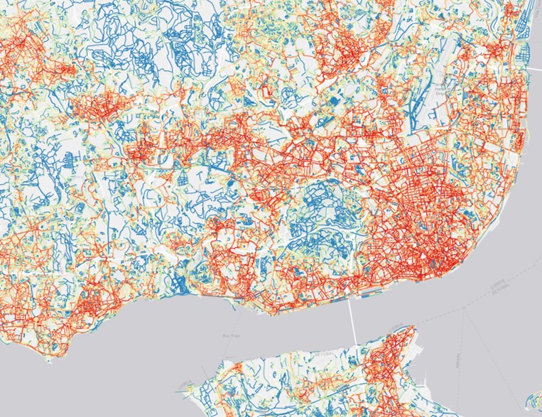
In summary: benefits of agent-based pedestrian traffic estimation compared with other methods
The following table shows the advantages of replacing or complementing other methods with agent-based mobility simulation:
| Method | National coverage | Scalability | Marginal cost per new location | Structural Origin-Destination | Classification by motivation | Scenario simulation capability | Methodological standardisation |
|---|---|---|---|---|---|---|---|
| Manual count | No | Limited | High | No | No | No | Low |
| Mobile SDK data | No | Medium | Medium | Observed trajectories | Limited inference | No | Medium |
| Mobile phone data | Partial | Medium | High | Macro-level aggregate | No | No | Medium |
| Mobility simulation (agents + Monte Carlo + predictive calibration) | Yes | High | Low | Yes | Yes | Yes | High |
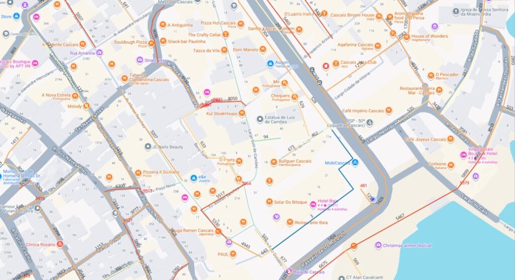
And in the following image we see the result of the simulation in just a few streets. The question is no longer only how many people pass by, but what type of pedestrian traffic passes by, why it passes by and what opportunity it represents. On which street would you open your business?
Conclusion
Pedestrian traffic in Portugal cannot be analysed solely as a point-based count. Having a structural estimate based on mobility simulation, agents, Monte Carlo and predictive calibration dramatically improves:
- The economics of analysis.
- Decision speed.
- Comparability between locations.
- Integration with point-based validation.
- The ability to anticipate future scenarios.
- The extension of methodologies calibrated in Spain to Portuguese markets through comparable territorial variables.
The methodological key lies in combining simulation and evidence: Spain’s public mobility data based on mobile phone records allow us to train mathematical models that learn how territory and mobility are related. Since the same explanatory variables can also be built in Portugal, we can estimate Portuguese pedestrian traffic with a robust, scalable and homogeneous logic.
If you want to learn more and test our pedestrian traffic simulation in Portugal, you can form-test our geoenrichment API or ask us for a test access.